Submitted by Quest-News-Serv... on Wed, 09/30/2015 - 23:17.
WE REMAIN ON RECORD TO SAY UNLESS DRASTIC CHANGES OCCUR IN TODAY'S COMPUTER MODELS, THE MARYLAND AND THE ENTIRE MID-ATLANTIC REGION COULD EXPERIENCE IMPACTS THAT EXCEED ISABEL IN 2003, IRENE IN 2011, SANDY AND HAZEL IN 1954.
- 2 PM NHC Advisory shows Joaquin becoming a major hurricane by Saturday morning with winds of 110 mph. By Friday night, coastal areas of NC/VA and Ocean City, MD will begin experiencing swells and with tidal rise, followed by gusts to Tropical Storm force on Saturday, and then hurricane force winds by early Sunday.
- Our preliminary landfall projection is between Morehead City, NC and Kill Devil Hills, NC by early Sunday morning as a Category 2/3 with winds of 110 mph.
"She's Got The Look."
- 1988 single by Roxette from the zlbum Look Sharp!
Your eyes do not deceive: That is a track directly up the Chesapeake Bay.
Although tracks change, it is an indication of how serious this storm could become.
- 2 PM NHC Advisory shows Joaquin becoming a major hurricane by Saturday morning with winds of 110 mph. By Friday night, coastal areas of NC/VA and Ocean City, MD will begin experiencing swells and with tidal rise, followed by gusts to Tropical Storm force on Saturday, and then hurricane force winds by early Sunday.
- Our preliminary landfall projection is between Morehead City, NC and Kill Devil Hills, NC by early Sunday morning as a Category 2/3 with winds of 110 mph.
4:00 PM 9/30 - Discussions within our Tropical Team in the past several days regarding Joaquin's path and potential impacts compels us to raise the following issues concerning preparation and public awareness.
FIRST, the most critical point to understand above all other aspects of this storm:
Significant and widespread impact from heavy rain, tidal flooding and strong winds is very likely over a large area of the Northeast U.S. even if Joaquin never makes landfall in the Mid-Atlantic. While we recognize it is human nature to avoid conflict and seek an easier solution, in the case of hurricanes, a weakening Category 2 storm is no less dangerous than a strengthening Category 1 storm.
SECOND, as depicted in the satellite imagery, it is clear to us that Joaquin "has the look" of a powerful hurricane which has the capability to inflict tremendous damage. What does "the look" comprise? It's a storm which has established a stable environment in which to rapidly intensify, according to these observations:
- Evenly distributed and consistent upper level "outflow" shield of clouds spreading from the center. This indicates a high pressure system is providing ample "exhaust" of rising heat and moisture away from the center via the top of the eyewall.
- "Central Dense Overcast" area of rapid thunderstorm bands forming in the eyewall as it wraps around the core.
- Stable cloud cover in all four quadrants of the storm and lacking a ragged edge along the western or southern side, thereby preventing dry air entrainment which can disrupt the core.
THIRD, the multi-hazard conditions that will be in place before the storm's arrival set it apart from Hurricanes Isabel, Irene and Sandy - and under current projections, may produce effects greater than any of those three. Consider the large extent to which probability of tropical storm force winds is already at 30-40% for 5 days from now.

- Several days of heavy rain has already produced significant flooding in parts of the Mid-Atlantic. This is not a pre-condition that was observed in any of the 3 previous storms.
- Joaquin is projected to slow down upon approach to the Mid-Atlantic. This is in contrast to the troika of hurricanes since 2003. All three moved through the area at a relatively rapid pace. Isabel picked up forward speed to over 25 mph, Irene at one point was moving 40 mph after grazing Ocean City, and Sandy was averaging 15 mph most of its life cycle.
- A slowing storm that is strengthening its sustained wind speed is an even worse combination. Once the hurricane begins to weaken in earnest, the wind field will rapidly expand to encompass a very large area of the Northeastern Corridor. It is not unreasonable to estimate that by Sunday afternoon, sustained tropical storm force winds may extend from New York City to Washington, DC and for a hundred miles inland.
- Storm surge projections, while not officially available yet, can be estimated in a general sense by comparison to past storms. If Isabel path traveled 50+ miles to the west of the Cheseapeake, and produced 4 feet of surge in the Bay, it is realistic to infer that an equally strong hurricane traveling up the Bay could produce double the surge due to the geographic magnifying effect of water being forced up inlets and small rivers.
We welcome your lessons learned from Isabel, Irene or Sandy as we all look for support from each other in preparation for another major storm that by all accounts, definitely has the look. - Forecaster Foot and the Tropical Team
11:00 AM 9/30 - As of the
latest NHC advisory, Joaquin's projected path continues to shift west, and the cone of uncertainty / potential areas affected would encompass the entire Northeast megalopolis from Norfolk-Richmond to southern New England.
Our team is preparing decision graphics for posting this afternoon, that we hope readers will find useful as we recommend taking advantage of today's relatively low rain environment to initiate prudent preparatory actions for your family and property.
- WE REMAIN ON RECORD TO SAY UNLESS DRASTIC CHANGES OCCUR IN TODAY'S COMPUTER MODELS, THE MARYLAND AND THE ENTIRE MID-ATLANTIC REGION COULD EXPERIENCE IMPACTS THAT EXCEED ISABEL IN 2003, IRENE IN 2011, SANDY AND HAZEL IN 1954.
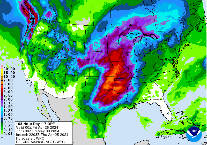
NOAA 7-day Rainfall Projections
Additional 8-10" is likely for areas shown in orange along the East coast.
9:00 PM 9/29 - As our team continues monitoring the progress of Tropical Storm Joaquin, today's run of computer models is getting more extreme with each passing hour. Some projections we've seen internally for this storm are beyond insane and would, quite literally, be a disaster that by some interpretations could exceed Isabel (2003, shown left) Irene and Sandy were these to come true.
Those who know us well and have been on this page a while understand we do not not hang our hat on just one model map and say, "there's our forecast, done!" We prefer to be honest and upfront about forecast uncertainty, especially when accounting for erratic tracks of tropical systems 1,000+ miles away. So, herein lies the challenges we all face with this storm:
1) The rain falling now will be a MINIMUM of 3-6" now to Thursday, with another 3-4" on top of that this weekend, even if Joaquin never touches land. These rainfall forecasts may exceed what Sandy did in 2012. Areas of southwestern Virginia are already seeing major flooding and washed out bridges, before a tropical system arrives. Consider this rainfall forecast from NOAA for the next 7 days. That orange is 8-9" of rain. Have you ever seen a map with that much rain forecasted from North Carolina to Maine?
4:00 PM 9/29 TROPICAL TEAM UPDATE
- Additional ocean moisture may confound rainfall forecasts due to an easterly fetch ahead of Joaquin. This would produce another 4-5" of rain if the system tracks closer to, or makes landfall on, the coast. Significant flooding will become a hazard to travelers during the AM and PM commute Wednesday through Friday.
- If you have critical outdoor priorities, we strongly advise rushing those to completion, as rainfall will be extremely heavy at times overnight once it begins in your area.
11:00 AM 9/29 UPDATE BY THE TROPICAL TEAM
Share
anti-speciesism - Quest, ministries - gofundme - please donate
http://realneo.us/content/anti-speciesism-quest-ministries-gofundme-plea...
http://www.gofundme.com/42dq3w
or
PAYPAL
https://www.paypal.com/cgi-bin/webscr?cmd=_donations&business=7424SY7WQM6F4&lc=US&item_name=Quest%2c%20inc%2e¤cy_code=USD&