SearchUser loginOffice of CitizenRest in Peace,
Who's new
Subscribe |
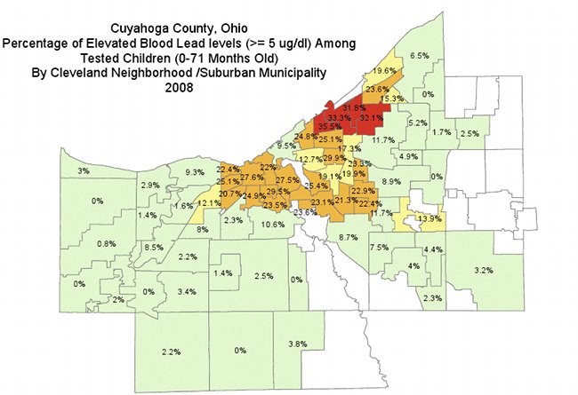
Lead Poison map - Euclid Corridor and East Cleveland are RED -Submitted by Jeff Buster on Fri, 11/02/2012 - 16:30.
Norm Roulet put up a report about lead a few years back on Realneo here. He included the map above. If one considers that the prevailing winds are from the west - then what would be your explaination of the highly lead poisoned RED areas on the map? Think about other cities and areas in those cities which might be down wind from coal fired industry operations. Is there any consistency? I am thinking of Baltimore near John Hopkins Hospital. I am thinking of Boston near Mission Hill. How about in PIttsburg? I don't know Pittsburg well so someone jump in here. We know that lead, mercury, arsenic, ozone, and carbon particulates spew from fossil fuel fired factories, steam plants, electrical generating stations, and industry. Put a pin in the map where the tall smokestakes are, and pencil in down wind an expanding plume. Do it in Detroit. Do it in ChiTown. Do it in Youngstown. What do you see? Put a pin in Cleveland Thermal's effluent exhaust externalities stack!
( categories: )
|
Support Civic Journalism Recent comments
Popular contentToday's:
All time:Last viewed:
|